


A downloadable PDF preprint from bioRxiv:
Genetic landscapes reveal how human genetic diversity aligns with geography
Benjamin M Peter, Desislava PetkovaThis article is a preprint and has not been peer-reviewed.
Abstract
Summarizing spatial patterns in human genetic diversity to understand population history has been a persistent goal for human geneticists. Here, we use a recently developed spatially explicit method to estimate “effective migration” surfaces to visualize how human genetic diversity is geographically structured (the EEMS method). The resulting surfaces are “rugged”, which indicates the relationship between genetic and geographic distance is heterogenous and distorted as a rule. Most prominently, topographic and marine features regularly align with increased genetic differentiation (e.g. the Sahara desert, Mediterranean Sea or Himalaya at large scales; the Adriatic, inter-island straits in near Oceania at smaller scales). We also see traces of historical migrations and boundaries of language families. These results provide visualizations of human genetic diversity that reveal local patterns of differentiation in detail and emphasize that while genetic similarity generally decays with geographic distance, there have regularly been factors that subtly distort the underlying relationship across space observed today. The fine-scale population structure depicted here is relevant to understanding complex processes of human population history and may provide insights for geographic patterning in rare variants and heritable disease risk.
In population genetics for public consumption, there’s a long-standing Is The Glass Half-Full or Half-Empty debate over whether human genetic diversity is clustered or clinal. It’s often argued that Race Does Not Exist because humans are distributed clinally, so a person in say, central Russia doesn’t look all that different from, say, a Dutchman.
That’s true, but it’s also true that there are some fairly strong geographic barriers to intermixing, such as the Sahara and the Himalayas.
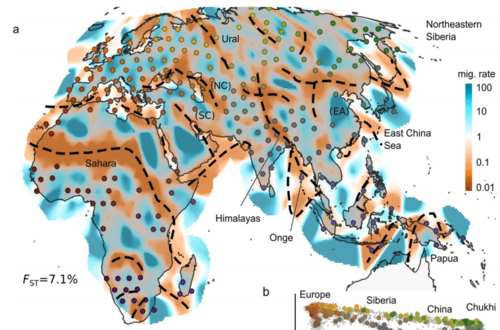
For example, in the map above, you can see a wide blue (clinal) region in Northern Europe from roughly Ireland to the Urals. Also, at the place marked by “NC”, corridor bends down from steppe to India: the famous old Northwest Frontier of the Raj, through which the British government feared the Czar’s army would invade, and through which, apparently, the Aryans did invade from the steppe thousands of years ago.
On the other hand, there are lots of geographic barriers (marked on the map in orange-brown) to gene flow as well, such as the Sahara Desert.
Actually, 2 dimensional maps like this that are centered on the Old World tend to distract from the two most important geographic barriers to gene flow as of 1491: the Atlantic and Pacific Oceans.
The Atlantic was particularly impervious. Although the Vikings briefly made it across the Atlantic to the New World, they didn’t leave much of a genetic footprint (although American Indian tribes are understudied for legal reasons, so there may possibly be interesting discoveries to come). Virtually all the migration from the Old World to the New World came in a small number of waves across what’s now the far northern Pacific (e.g., the Bering Strait or what was an Ice Age landmass we call Beringia).
But, so far as we know, before 1492 nobody got back and forth between Africa and South America across the Atlantic.
In the Pacific, Polynesians got as far as Easter Island a couple of thousand miles west of South America. And the South American sweet potato in Polynesia may suggest a few interchanges. And there’s a tiny amount of DNA evidence in the Amazon region suggesting Old World peoples got there before the Polynesians, but everybody is pretty baffled by it.
The Indian Ocean was less of a barrier, since its northern shore was mostly quite habitable, except in deserts and mountains. (The hills of Burma are an underrated barrier). There was even a migration directly across the breadth of the open Indian Ocean in pre-1491 times from Southeast Asia to Madagascar.
Awhile ago an iSteve commenter pointed out something interesting about the Sahara as a barrier to gene flow: to travel south from Algeria is more like a one-two punch or double filter: first, the Sahara and then the fever belt of the tropical rainforest of west and central Africa.
Mediterranean and Arab peoples who made it in small numbers across the Sahara have mixed race descendants in the Sahel (e.g., Timbuktu on the southern edge of the Sahara was culturally part of the main Muslim world, with a library, for example.) But getting through the wet tropics to the south was murder for anybody without the proper anti-malaria genes. Thus, in John Updike’s 1978 novel The Coup, the narrator, the Muslim Marxist dictator of a fictitious Sahelian country called Kush (like Mali or Chad), dismissively writes of Africa to the south of the dry zone:

This double filter doesn’t really show up in this map: sub-Saharans acclimated to the wet tropics can live in the dry Sahel along the Niger River, but northerners can’t get past the Sahel, and there’s not much profit to them in farming the Sahel in large numbers.