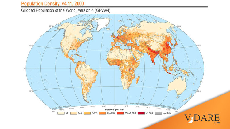
A map of global population density is useful in helping to grasp where racial boundaries tend to fall:
![]()
Yesterday, I mentioned the vast empty space in the Sahara, which is a big reason why Sub-Saharans don’t blend in that much genetically with the rest of the world, outside of the Horn of Africa.
But also note the sharp distinction between South Asia and Tibet.
And across the medium latitudes of Eurasia (e.g., ~40 degrees north, such as Madrid and Beijing), while there are blended populations like the Uighurs, the vast majority of peoples can be grouped reasonably into either Europeans or East Asians. The center of Eurasia, with its unpleasant climate, tends to support fewer people than either the Atlantic or Pacific ends.
Most of all, there are huge oceans. Some, such as the Indian Ocean, were not impassable to pre-Age of Exploration shipping. The Pacific was more difficult to get across, although the Polynesians eventually crossed most of it. And the Atlantic was a massive challenge, outside of the far north. (But there wasn’t much profit for the Vikings, so they didn’t do much with their brief foray to North America.)
From Vox, here’s somebody’s estimate of world population density in 1491.
![]()
This could be wrong in places. For example, a theory that has been growing in popularity is that Amazonia might have had a more sizable population in 1491 than you’d imagine from how empty it is now.
And I wouldn’t be surprised if the population of American Indians would have grown rapidly over the last 500 years (due to the adaptation of Mexican corn [maize] to higher latitudes) if not for Old World infectious diseases.
On the other hand, David Reich argued recently from genetic data that Hispaniola appears to have been much less populated than Columbus reported.
But the 1491 map shows pretty clearly that the main racial groups used by the U.S. government as being good-enough-for-government-work are based on major geographic barriers between populations.
The main criticism I’d make of Blumenbach’s 1795 five-race summary was that lumping South Asians in with Europeans-North Africans-Middle Easterners as a vast Caucasian race might be too lumpish. Granted, it captured the steppe invasion that had so much influence on Europe as well. On the other hand, South Asia is such a large concentration of people that it might be better to split them out as their own race. But then, that bumps up against the high social barriers within South Asia. So, South Asia remains a conceptual conundrum for splitters or lumpers.
[Comment at Unz.com]